Showing posts with label Maps. Show all posts

22 May 2017

Canals ~ Early Disruptive & -ted Infrastructure!

Bill Warner spotlights how Before the Internet, There Was the Middlesex Canal...
"When you take a look at the history of the Middlesex Canal, built from 1794 to 1802, you’ll find a surprising similarity between the issues facing technology investors today, with those over 200 years ago. [...] The technology of moving goods at great scale and at low cost started with the Middlesex Canal. Then the railroads took over. Now containerization [...] Like all technology change, those in control of the current technology fight hard to hold on [...] But the march of technology is relentless when new approaches cut costs and increase speed."
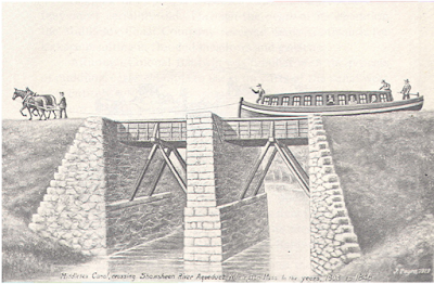
https://medium.com/@billwarner/before-the-internet-there-was-the-middlesex-canal-cb853cc80891 Be especially sure as you read Bill's story to check out his MapJunction tool to visualize the historic pathway overlaid over contemporary photo-map!

02 June 2013

Fertile Continent ~ Detailed Soil Atlas of Africa...

Thanks to Emeka Okafor at Africa Unchained for spotting the new Soil Atlas of Africa...
"Using state-of-the-art computer mapping techniques, the Soil Atlas of Africa shows the changing nature of soil across the continent. It explains the origin and functions of soil, describes the different soil types that can be found in Africa and their relevance to both local and global issues. The atlas also discusses the principal threats to soil and the steps being taken to protect soil resources. [...] It presents a new and comprehensive interpretation of an often neglected natural resource."

01 April 2013

Evidence of Commerce ~ Obsidian Archeonomy!

Obsidian allows for archeological economics points out Matt Ridley in WSJ Mind & Matter column on A King's Overreaching, Traced in Black Glass...
"Obsidian was once one of humankind's most sought-after materials, the "rich man's flint" of the stone-age world. This black volcanic glass fragments into lethally sharp, tough blades that, even after the invention of bronze, made it literally a cutting-edge technology. Because sources of obsidian are few and far between, obsidian artifacts are considered some of the earliest evidence of commerce: Long-distance movement of obsidian, even hundreds of thousands of years ago, suggests the early stirring of true trade. Differences in the trace elements in each volcanic source let archeologists trace the origin of individual obsidian artifacts and reconstruct trade routes. A new study [Environment and collapse: Eastern Anatolian obsidians at Urkesh (Tell Mozan, Syria) and the third-millennium Mesopotamian urban crisis] by Ellery Frahm of the University of Sheffield and Joshua Feinberg of the University of Minnesota, has used such obsidian tracing to shed light on how trade collapsed in the Akkadian empire of the early Bronze Age around 4,200 years ago in what is now northern Syria."
Fascinating! Here's just few of the study maps & data...

04 January 2013

Balloon Mapping ~ Try DIY Aerial Cartography...

If you buy one of these Balloon Mapping kits...
...and follow handy illustrated guide...
...combining in a camera, a sodabottle, and some handy helium...
...then you accumulate aerial pix floating over a topography...
...and stitch them together via MapKnitter or the like... ...then you've done some lovely DIY cartography. Thanks PLOTS!