"A new look at antique US railroad maps reveals how cities grew over the past 200 years. The FT's Alan Smith and Steven Bernard trace how cities, people and the economy spread from coast to coast"

Exponential Innovations Everywhere
* * *
Joost Bonsen's Opinions on How Money, Ideas, and Talent can
Enable Health, Wealth, and Happyness for Each plus Achieve Liberty, Prosperity, and Vitality for All and Ultimately Help Us Spread Beyond Our Cradle Planet Earth
"A new look at antique US railroad maps reveals how cities grew over the past 200 years. The FT's Alan Smith and Steven Bernard trace how cities, people and the economy spread from coast to coast"
"Developed for you at our company, InMeteo [...] a Czech meteorological company based in Pilsen. At our company, we focus on weather prediction and meteorological data visualisation. [...] The name itself, Ventusky, is a combination of two words. The first is the Latin word, Ventus, means wind, and the second is the English word, Sky. The Ventusky application is freely accessible to anyone around the world, aimed at improving awareness about meteorological events in our atmosphere. Images from the application can be redistributed and thus help us achieve our goal."


"America is increasingly divided not between red states and blue states, but between connected hubs and disconnected backwaters. [...] Federal policy should refocus on helping these nascent archipelagos prosper, and helping others emerge, in places like Minneapolis and Memphis, collectively forming a lattice of productive metro-regions efficiently connected through better highways, railways and fiber-optic cables: a United City-States of America. Similar shifts can be found around the world. Despite millenniums of cultivated cultural and linguistic provinces, China is transcending its traditional internal boundaries to become an empire of 26 megacity clusters with populations of up to 100 million each, centered around hubs such as Beijing, Shanghai, Guangzhou and Chongqing-Chengdu. Over time these clusters, whose borders fluctuate based on population and economic growth..."

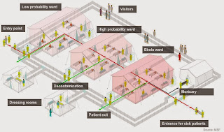
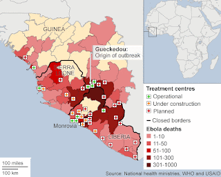
"The treatment centre is designed to separate confirmed Ebola patients from probable or likely cases. Upon entry, patients are examined by medical staff in full protective gear. Following the initial diagnosis, they are then split into low or high probability wards until the laboratory results come in, which could take anything from a few hours to days, depending on the facility. There is little that medical workers can do for their patients, as there is no cure for Ebola. All they can help with is to care for the patients and treat symptoms like dehydration, as well as wash and comfort them. According to MSF, good care increases the chances of survival from a disease that has a 50% fatality rate and whose symptoms include vomiting, diarrhoea and bleeding, sometimes from the eyes and mouth. However, overcrowded facilities and a shortage of staff on the ground have made this difficult so far."


 And here vs Silicon Valley centered on Stanford...
  Vs Cape Town...
  Vs Doha...
  Vs Aqaba+Eilat...
  Vs Mumbai...
 Thanks to MapPorn for spotting.

"Developed by Gnip, MapBox and tech-data expert Eric Fischer, the maps reveal that the iPhone are overwhelmingly used in the most densely-populated urban areas while the Android is more popular in the suburbs. Mapbox CEO Eric Gundersen said: 'The patterns of usage in each city often reflect economic stratification. 'For example iPhones, in red, are predominantly in wealthy sections of the city while Android phones, in green, have more coverage in poorer sections."Here's New York Metro centered on Manhattan...
 Texan sprawlcity Houston...
 Indonesians in Jakarta prefer Blackberry, colored purple...
"The world [...] is spiky, with its most intensive economic activity concentrated in a relative handful of places. Global tech is no exception -- and it is taking a decidedly urban turn."


.svg.png)


